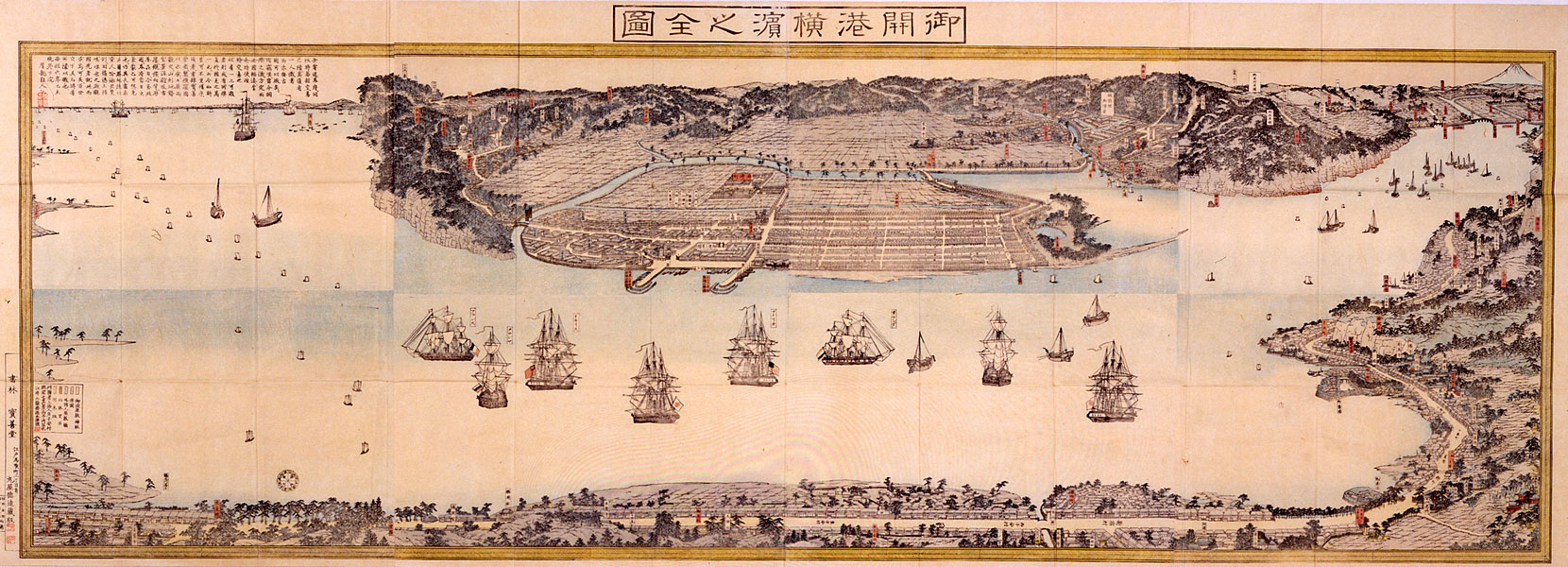
Gokaikō Yokohama no zenzu Title: Complete Picture of the Newly Opened Port of Yokohama Artist: Sadahide (1807-ca. 1878) Winter, 1859-60 Format: Woodblock print Medium: Ink and color on paper Dimensions: Eight sheets joined and folded: 69.5 x 191.1 cm (27 3/8 x 75 1/4 in.) Source: Arthur M. Sackler Gallery, Smithsonian Institution A magnificent topographical view of the new town of Yokohama is presented by this large landscape map. Published within the year after Yokohama opened, the print represents an impressive technical achievement. Assembled from eight oversized sheets of paper, each separately printed in several colors, it is one of the largest prints ever published in the traditional Japanese technique of woodblock printing. A lengthy inscription by a writer who signed with the nom de plume Setsuryū Sanjin is printed in the upper left corner: Once I wandered around the border area and asked where the trading firms were. No one knew where they were, nor was there a map to show the location. Therefore, I silently lamented. Now the opening of the port has been settled and the Five Nations [United States, Russia, France, Great Britain, Netherlands] have gathered here. If the conditions of the past had to be investigated to determine whether they had been profitable to our country, there would be no means to verify it. I could do nothing but regret this situation. Later, the publisher Hōzendō made a map of Yokohama. It was shown to me, and I saw the landscape, public buildings, Western-style houses, and urban buildings expanding in all directions. Now we see a map very clearly, so we can imagine the past phenomena of this area. A landscape painting is only for poets. Therefore, I encourage people to publish maps. If people want to see the scenery of this area, they can see them by means of this map, and they will still be able to see them one hundred years from now.The artist, Sadahide, who signs with an artistic name, Gyokuransai Hashimoto of Edo, declares in his inscription: "I have painted this picture en route to the capital [Kyoto]: a true view of the outlook from Koyasu Village." From his vantage point, the artist looks toward the new town of Yokohama, on the southwest shore of the bay. The Tokaidō, the busy highway linking Edo and Kyoto, runs along the near shoreline. Toward the right, the road passes through Kanagawa, the post town that was specified by the treaties of 1858 as the site for foreign commerce and residence. Sadahide, perhaps with the use of a telescope, depicted in detail the large ocean-going Western ships, Japanese coastal trading vessels, and the smaller ferries and fishing boats that filled the harbor of Yokohama and Edo Bay, which extends toward the right in this print. British horticulturalist, Robert Fortune, upon reaching Yokohama at the end of October 1860, described the scene in terms remarkably parallel to Sadahide's nearly contemporary print: "On our right, in the direction of Edo, we observed a cloud of boats under sail, composed chiefly of fishing boats which supply the markets of the capital and the surrounding towns with fish." Complete Picture of the Newly Opened Port of Yokohama expresses in its imposing scale and meticulous detail the artist's devotion to what must have been a demanding project. The continued popularity of the image during the years following the port's opening reflects its utility as a guide to the region and the brilliance of Sadahide's first great landscape of Yokohama. [Adapted from Ann Yonemura, Yokohama: Prints from Nineteenth-Century Japan] MIT Visualizing Cultures image number: [Y0044] Keywords: Yokohama, Kanagawa, Tokaidō, the Five Nations, United States, France, Great Britain, Netherlands, Russia, ships, steamships, flags, maps, foreign settlement |
On viewing images of a potentially disturbing nature: click here. |
Massachusetts Institute of Technology © 2014 Visualizing Cultures |