| |
TREATY-PORT IMAGERY & ITS IMPLICATIONS
In subscribing to the views and types protocol, Thomson was no different than most 19th-century commercial photographers working in Asia. This simple dichotomy provided a convenient means to organize and present large inventories to potential customers, and afforded a convenient means to organize the 81 scenic views and 119 types in Illustrations of China and Its People. Closer examination reveals that Thomson’s photographs also occupy several sub-categories within the views and types convention.
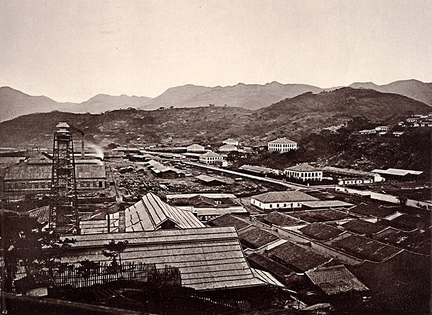
27 of Thomson’s scenic views—one third of the total—focus on the historical and contemporary presence of foreigners in China. Images of the treaty ports constitute the greatest proportion of these. This emphasis on the Western presence seems inordinately large. We need to ask, then, what purpose these photographs serve in Thomson’s travel narrative, but also—and more important—what they might convey about contemporary British attitudes toward China. 3
One can argue that Westerners were a feature of late-19th-century China, albeit a much smaller presence than Thomson would have us believe. The treaty ports would be among the first scenes travelers following his routes would encounter. For a country as large and unexplored as China was at the time, these foreign settlements undoubtedly functioned as havens that softened initial encounters with China and its people. In that they retained many essential features of Western cities, they provided sanctuaries where Westerners could retreat to the relative comfort of a familiar culture.
|
|
 |
| |
“In 1684 a small patch of land on the bank of the river at Canton was granted to the East India Company, with permission to erect a factory there, provided all their traders and trading operations were strictly confined within its circuit. This site, with its present boundary-wall and buildings, surrounded by the miserable makeshift huts of the poorest class of the population, is shown in the photograph annexed. It now forms the American Concession Ground, and its building are occupied by Messrs. Russel, and by Messrs. Smith Archer, two of the oldest American houses in China.” (from caption)
“The Old Factory Site, Canton”
plate XVI, volume 1 (detail)
ct1073 (caption) ct1074 (photo)
|
|
| |
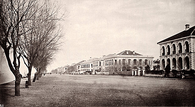
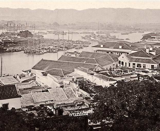
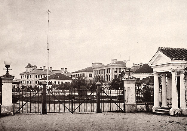
Thomson’s images of the treaty ports convey precisely this sensibility. He favors panoramic scenes that sweep across a harbor or views taken from higher vantage points so as to encompass wide swaths of the foreign settlements. With their whitewashed column-and-arch facades, the Western-style structures of the ports stand out from the gray and black tonalities of his photographs as if they are bathed in a special light.
Thomson also employed another particularly effective means of visually enhancing the Western presence in the treaty ports. For his street-level images of Kiu-Kiang and Hankow, he positioned his camera at an oblique angle looking down the main avenues of the settlements. This encourages viewers to scan up and down the street along the strong visual axis of the composition. When viewing the Hankow photograph from right to left, it appears as if the foreign presence extends beyond the horizon. Viewing in the opposite direction, the Western-style facades of the buildings emerge from the end of the street, where the effects of atmosphere blur their appearance, and appear to grow in size and come into sharper focus as they parade in a stately procession toward the viewer. Thomson constructs a visual analogy for the march of civilization engendered by the presence of Westerners in China.
|
|
 |
| |
“Kiu-kiang is the second open port on the Yangtsze, 445 miles above Shanghai. This port was selected as a suitable place for foreign trade, because of its close proximity to the Po-Yang Lake, and to the vast system of water communication which branches form this point to the interior. But as the lake is closed against steam traffic, and as Kiu-kiang stands fifteen miles above the confluence of the lake with the Yangtsze, it has never taken a leading commercial position.” (from caption)
“Kiu-kiang (Foreign Settlement)”
plate XIII, no. 24, volume 3 (detail)
ct3053 (caption) ct3054 (photo)
|
|
 |
| |
“The foreign settlement there has a frontage to the Yangtsze, but the plot of ground on which it has been built is unfortunately lower than that occupied by the native town. Why this site should have been selected it is impossible to tell. The mistake is one which the natives themselves would never have committed, and it has entailed great suffering during times of flood.” (from caption)
“Hankow (Foreign Settlement)”
plate XVI, no. 31, volume 3
ct3063-ct3064 (caption) ct3068 (photo)
|
|
| |
Thomson’s captions and commentaries often reinforce the visual presentation of Western-style buildings. For his image of the foreign settlement at Foochow, he writes:
The settlement boasts an excellent club, library, and racket court, while the climate for six or eight months of the year is favourable to outdoor amusements. Many varieties of European flowers and vegetable are grown here to great perfection by the Chinese gardeners. It is altogether a sort of place where foreigners may well be content to reside. Here, as also in Amoy, there are a number of protestant and Roman Catholic missions in active operation. There is also a prettily built English church, opposite which the Chinese has erected a small shrine, where incense is burnt by devout Buddhists to counteract the influences of the Christian place of worship. Close to the church there is an English mortuary chapel and cemetery shade with a group of tall, dark pines.
In short, Thomson suggests that Westerners could recreate, eat, be ministered to, die, and be buried in Foochow in ways not unlike what they might expect in their home countries.
|
|
 |
| |
“Foochow Foreign Settlement”
plate XVI, no. 43, volume 2 (detail)
ct2066 (caption) ct2067 (photo)
|
|
| |
To viewers of Illustrations of China and Its People, Thomson’s treaty ports would appear not only inviting but also capable of becoming agents of transformation. The caption for his photograph of the Foochow arsenal, for example, links the presence of foreigners to the modernization of China:
This Chinese arsenal, or naval training school, as I might more correctly describe it, is to me a very great proof of modern progress in the empire, and marks the dawn of a new era in Chinese civilization. … [T]he Chinese have become aware that to study their ancient classical literature, or to con the maxims of their sages, is not the kind of education which will fit them to cope with their near neighbours, who are adopting the customs, arts, and sciences of the West.
|
|
| |
“Foochow Arsenal”
plate XV, no. 42, volume 2
ct2064 (caption) ct2065 (photo)
|
|
| |
Thomson provided brief historical synopses for most of the locales he photographed. For his images of Shanghai, he emphasizes the city’s openness to foreign trade even before the treaty ports were formally established, and suggests the potential this relationship holds for China:
China will sooner or later be forced to press forward in the march of civilization, as her Japanese neighbours are fast discovering the secrets of Western power. When that time arrives, the Chinese will find the elements of all they are in search of at the foreign settlements in Shanghai, where the schools, the splendid commerce, the merchant palaces, the fleets of steamers, the local foreign government, the opulence of the inhabitants, and the condition of the streets and dwellings, offer an instructive contrast to the condition of the Chinese walled city which lies to the south of the foreign settlements.
|
|
 |
| |
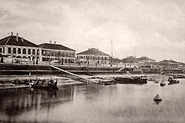
“The treaty of Nanking was concluded in 1842; but even before that time Shanghai was a place of considerable trading importance.” (from caption)
“Part of the Shanghai Bund in 1872”
plate V, no. 8, volume 3 (detail)
ct3025 (caption) ct3027 (photo)
|
|
| |
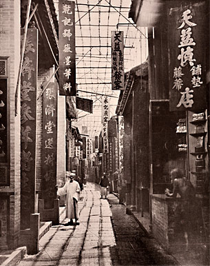
The large number of treaty-port photographs provokes comparisons with Thomson’s treatment of Chinese cities. How did he present and characterize the built environments of China, and what might this reveal about his attitudes and those of his readers? The caption for his photo of a market in Canton provides some clues. It begins with a general discussion of Chinese streets and the shops that line their sides, including the typical experience one might have upon entering a shop and interacting with its proprietor. Thomson concludes this part of the caption by commenting favorably on the visual appearance of the view presented:
|
|
 Physic Street, or, more correctly, Tsiang-Lan-Kiai (our Market Street), as the Chinese term it, is one of the finest streets in Canton, and, with its varied array of brightly coloured sign-boards, presents an appearance no less interesting than picturesque. Physic Street, or, more correctly, Tsiang-Lan-Kiai (our Market Street), as the Chinese term it, is one of the finest streets in Canton, and, with its varied array of brightly coloured sign-boards, presents an appearance no less interesting than picturesque.
|  |
“Physic Street, Canton”
plate XX, volume 1
ct1086-ct1087 (caption) ct1088 (photo) |
| |
But Thomson then extends his commentary as follows:
The streets of the city of Canton are irregularly built and tortuous in their course; those of the poorer sort are much narrower than the one shown in the photograph; they are badly kept, filthy, and even more offensive than the most crowded alley in London, the right of way being contested between human beings, domestic pigs, and undomesticated mongrel curs.
It is important to note the discursive strategy Thomson employs here, for it is more sophisticated than a simple comparison of the good and bad features of Chinese streets. Determined to protect the aesthetic integrity of his photograph, he directs his disparaging comments towards a subject not shown in the image but conjured up through comparison with a London slum. Thomson thus resolves the tension between his inclinations as an artist/photographer seeking out aesthetically interesting subjects and his role as correspondent speaking to the assumptions and expectations of his Western audience.
This approach enables readers to adopt a similarly bifurcated attitude towards China. Like Thomson, they can both admire and critique China by negotiating the differences between the picturesque qualities of the image and the far more negative characterizations that inflect his captions. In this particular case, the caption concludes with translations of several of the signs in the photograph, for which Thomson relied on W. F. Mayers, a scholar of Chinese. Thomson often cited experts and scholarly texts to give authority to his commentaries.
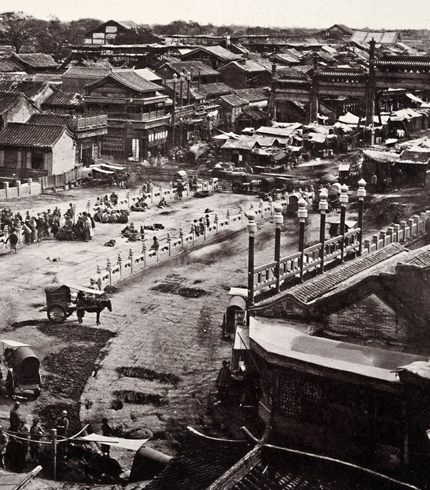
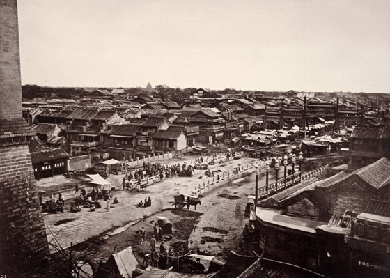
Thomson adopts a similar strategy for his view of Peking’s central avenue. This artery, which extended from the main gate on the southern extremity of the city to the Forbidden City and residences of the emperor, was designed to impress visitors as they moved toward the administrative heart of the empire and the emperor himself. The avenue also provided a stage for imperial processionals moving from the Forbidden City to the Temple of Heaven (appearing on the horizon just left of center), where the emperor—the son of heaven—made annual sacrifices for the benefit of the nation. Paved with stones and passing through massive gates and pailau (ceremonial arches), this avenue represented imperial authority and the order it brought to Peking and, by extension, the nation.
|
|
 |
| |
“This view (No. 21) is taken from the city wall of Peking, close to the Ching-yang-men, or central gate, between the Chinese and Tartar quarters. It is in a direct line with the centre of the palace, and is the route which the Emperor traverses on his way to the Altar of Heaven. In the foreground we see a white marble bridge which spans a kind of city moat. This street, like all the thoroughfares in the Tartar city, is a very wide one, and is a place of great concourse and traffic.” (from caption)
“The Central Street, Chinese City of Peking” plate IX, no. 21, volume 4
ct4041-ct4042 (caption) ct4043 (photo)
|
|
| |
Thomson points out these features, but focuses his attention not on the imperial presence but rather on the disorder encroaching on the avenue. He notes that vehicular traffic, apart from that of the emperor, is forbidden on the arched bridge in the center of the photograph, but then draws attention to the beggars congregating there “gambling in groups, or stretched upon the pavement to expose their sores and nakedness to the public gaze.” For the cramped cluster of stalls between the bridge and the pailau, Thomson adopts the same strategy employed with his photograph of Physic Street in Canton: he narrates not his experience with the avenue shown in the photograph, but rather with of one of the cramped side streets intersecting it:In the center of each street a raised causeway has been made, broad enough to accommodate two carts abreast, and is intended for carriage traffic. Between this raised causeway and the shops on either side of the road run broad spaces taken up with booths, tents, and stalls so closely packed as only to leave a narrow footpath close to the shops on the one side, and a chasm of deep mud pools on the other. From these pools material is taken for plastering and repairing the raised causeway. Most of the pools are stagnant and extremely polluted. One of my most disagreeable experiences during my visit to Peking was a ride along the road whilst the mud form these putrid pools was being ladled on the highway to lay the dust. The dust, indeed, was laid, but fume like those of the decomposing dead were raised in its stead.
In both image and caption, then, China’s imperial capital compares poorly to the order and cleanliness of the foreign settlements that appear throughout Illustrations of China and Its People.
|
|
| |

|
|
|