| |
Edo
16 photographs in the Hood Museum album are of sites in Edo—a remarkable concentration of images. The next largest grouping consists of twelve photographs taking in a wide range of sites spread along the Tōkaidō through the Hakone district to the Fuji highlands. The emphasis on Edo is explained by its preeminence in Japanese history and mid-19th-century politics. It served as the capital of the Tokugawa government from 1600 to 1868. At the time the Hood Museum album was being compiled, the Shogunate had been dissolved in favor of a restoration of imperial rule. Edo, about to be renamed Tokyo, would retain its position as national capital but assume a new role as the poster child for the Westernization of Japan. Edo’s proximity to Yokohama—Beato’s main market—also accounts for the high profile it receives in this album.
The Edo section of the album actually begins with a photograph of a Buddhist monastery in Kawasaki, a small village on the Tōkaidō between Yokohama and the capital. As the caption notes, Kawasaki marked the eastern boundary of the treaty-port limits, beyond which foreigners required passports for travel.
|
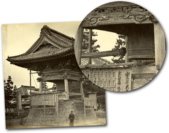 |
 The inset zooms in on the “Great Bell” in a Buddhist monastery. Westerners were intrigued by the way bells were rung by swinging a clapper from the outside. Special Buddhist names given to the deceased are displayed below on long wooden plaques. The inset zooms in on the “Great Bell” in a Buddhist monastery. Westerners were intrigued by the way bells were rung by swinging a clapper from the outside. Special Buddhist names given to the deceased are displayed below on long wooden plaques.
[bjh25]
|
The next photograph, a panorama titled Yedo Bay, functions as the visual entry into the capital. The caption emphasizes this reading of the photograph, then entices the viewer to enter the city and explore its wonders:
“Few capitals can boast so many striking features or so much beauty in its site and surrounding country as this, for many leagues in every direction—and the charming rides through country lanes, even its very center, shaded as they often are by trees of magnificent growth, from attractions which are unrivalled by any western city of corresponding size.”
|
|
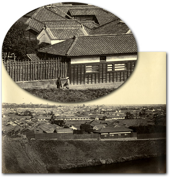 |
Beato’s photograph, “Yedo Bay,” gives an overview of Edo, Japan’s capital and most populous city that, the caption states,“lies encircling the head of a sickle shaped bay... so shallow that large vessels cannot approach within three or four miles.” The inset highlights two men walking the embankment in the foreground.
[bjh26]
|
The photographic tour that follows takes in temples, pilgrimage sites, gardens, and teahouses. The captions paired with these images enliven the cultural legacies and practices of the places Beato photographed.
By far, most of the Edo photographs depict places associated with the power of the shoguns. Six images (several appear below) show the mausoleums of the Tokugawa shoguns, all of which utilize the same caption describing the historical importance of the site and artistry of the structures. |
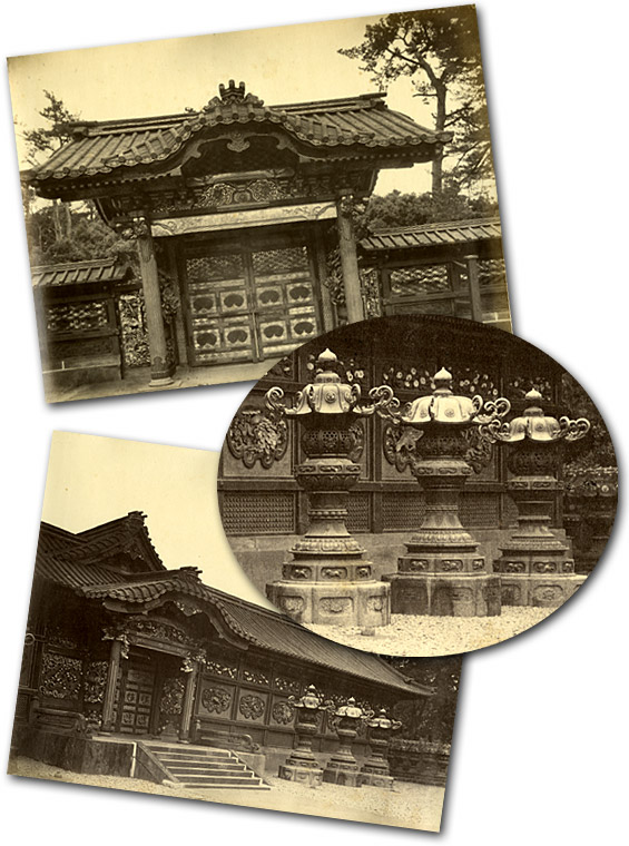 |
The mausoleums of the Tokugawa shoguns were among the most popular sites for foreigners touring Edo. The caption explains that the “Taikuns” are “buried either at Shiba or at Uyeno, in Yedo. … The view represents the gateway and front of a small, but highly finished temple. …”
[bjh30, 31]
|
Three photographs of Edo castle follow those of the mausoleums. Like those for the burial grounds, the captions emphasize historical associations with the Tokugawa shoguns or Tycoons (from Taikun), a term preferred by many 19th-century Westerners. But the captions for the images of Edo castle also draw on recent history. The text for Gateway of the Tycoon’s Palace, Yedo reminds viewers of the assassination of Ii Naosuke, the government minister who advocated the opening of Japan to foreign trade, on March 24, 1860.
|
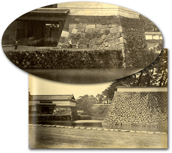 |
“Gateway to the Tycoon’s Palace” depicts the moat and stone wall surrounding the Shogun’s castle in Edo. Foreigners of Beato’s time called the Shogun “Tycoon” or sometimes “Taikun.” The inset, showing a visitor by the gate, conveys how massive the fortifications were.
[bjh36]
|
| The caption for the Castle of Yedo—Inner Moat (below) draws attention to the 1868 restoration of imperial rule, noting that the emperor now occupies the former residence of the shoguns. |
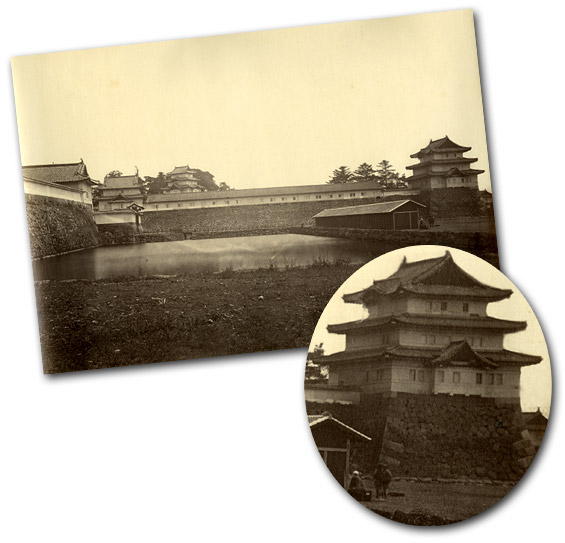 |
“Castle of Yedo,—Inner Moat.”
[bjh37]
|
This viewing sequence, from the photographs of the Tokugawa mausoleums to Edo castle, leaves one with the impression that Japan was on the cusp of change. The rapid westernization Japan would undertake shortly after the Meiji Restoration would initiate dramatic developments and, in the process, present new challenges and opportunities for Beato and his successors in the photography trade.
Yokohama
As noted, the captions for many of Beato’s scenic views seem intent on articulating the history of Western interaction with Japan. This practice is understandable given Beato’s market. These captions were designed to draw potential clients into an empathetic relationship with the places Beato photographed. Historicizing these images provided the means by which contemporary viewers could position themselves as participants in a relationship that stretched back centuries.
More recent developments in the West’s relationship with Japan also inflect the readings of some of Beato’s scenic views. Many Westerners, particularly diplomats, educators, and missionaries, saw themselves as agents of Japan’s transformation from a feudal backwater to a modern civilized nation. Captions that focus on the recent history of foreigners in Japan were a means of reaffirming this role. This is especially so with photographs of Yokohama. Because of its proximity to Edo, Yokohama housed the largest community of foreign residents. Photographs of the port and its immediate vicinity commemorate—perhaps even celebrate—the Western presence in Japan. Their captions focus on history so recent it was, for most of Beato’s customers, the present.
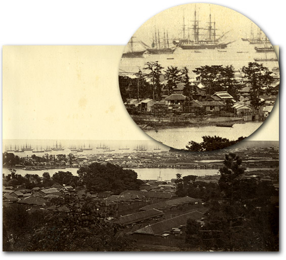
Photographs taken from the high ground overlooking the port were extremely popular because they afforded panoramic vistas of all that lay below. The Hood Museum album contains two such views. Both show the built environment of the port extending from the foreground out to the harbor, which is full of Western vessels. The caption for View from the French Bluff (below) sets foreigners’ experience in Yokohama in sharp contrast with that of the Dutch in Nagasaki by suggesting that the Japanese intended to replicate the same policy of “offensive espionage” that “had for so many years been pursued against the Dutch.”
|
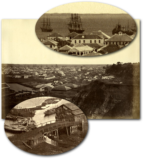 |
Close examination of the panoramic “View from the French Bluff” reveals many details of the Yokohama treaty port, from the entry bridges to the harbor bustling with merchant vessels. Within a few years of opening to trade, the Yokohama foreign settlement was already crowded with Western-style buildings.
[bjh44]
|
When Yokohama was constructed, the foreign settlement was built on reclaimed land separated from the shore by a creek shown in another photograph in the album (image 43, below). Access to the mainland was limited to bridges guarded by Japanese troops. The French Bluff, from which the above panoramic photograph was made, was the first area opened to settlement outside the port proper. The caption commemorates this development as resistance to Japanese plans to confine the foreign community of Yokohama.
|
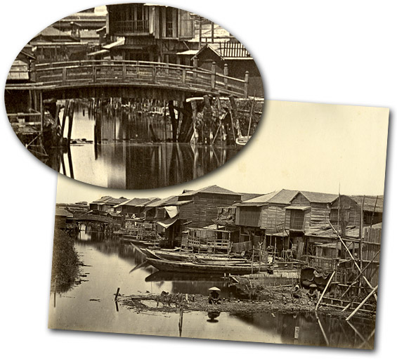 |
Depicted here are the creek that separated Yokohama from the mainland and one of the bridges that were guarded to monitor foreigners coming and going from the treaty port.
[bjh43]
|
The caption for the photograph titled simply Yokohama provides a skeletal history of the port. It notes that Kanagawa was initially designated as the future site of the foreign community but that the Japanese, for any of a variety of reasons cited in the caption, shifted the location to Yokohama. (The same caption was used for a photograph of Kanagawa earlier in the album.)
|
 |
The variety of buildings in both the foreign quarter and the so-called “native town” of Yokohama, as well as the large number of ships in the harbor, make a lively portrait of Yokohama as a “boomtown.” This photo conveys an unusually good sense of how busy the harbor had become.
[bjh45]
|
The caption then traces the subsequent development of Yokohama, noting “at the end of the third year from the opening of the Port the foreign community numbered 126; from that time, however, it has multiplied considerably.” It discusses the great fire of 1866 that “swept away a large portion of the native town and about one-third of the foreign settlement.” The fire was personally disastrous for Beato and Wirgman as it destroyed their business premises and their stock of negatives. This caption concludes with speculation on the bright future of Yokohama: “In January 1867, the first of splendid steamers belonging to the Pacific Mail Steam-ship Company made her appearance from San Francisco; as the Head Quarters of the Company in the East are at Yokohama, an additional guarantee is afforded for its future consequence.” This would prove to be a momentous event for the future of commercial photography in Japan. Trans-Pacific travel would become a key component of the routes that would carry globetrotters on their world tours. Beato’s business was one of the first in Yokohama to profit from this development. The ships shown in the harbor of his Yokohama photographs attest to the importance of the busy port, and at the same time remind us of the flow of customers for Beato’s albums.
Another view of Yokohama shows the so-called New Road, built by the Japanese in order to link Yokohama with the Tōkaidō.
|
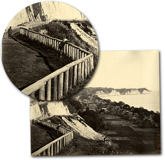 |
One of the loveliest images in the album depicts the pristine new road the Japanese built to link Yokohama with the Tōkaidō highway.
[bjh23]
|
Following the protocol for other Yokohama views, the caption for this image gives a brief description of the road: “It was completed in 1866, and is about six miles in length, winding through a varied, undulating, and pretty country. The view from the hill overlooking Mississippi Bay, which this road also skirts, is particularly attractive.” The caption then focuses on the construction of a horse-racing track and other facilities completed in 1867 to house the British Legation.
The New Road opened up much needed land for the expansion of both the foreign and Japanese communities of Yokohama. The caption notes that a lot of property was sold at auction and that “Many of these lots were purchased at a high price, and now, in the beginning of 1868, the whole space between these limits is intersected by numerous roads, and in every direction, bungalows and gardens, the property of foreigners, are springing up.” The potential profits in land speculation must have been attractive to anyone in Yokohama with an entrepreneurial eye. Even Beato entered this business. A notice he placed in the February 9, 1870 edition of the Japan Weekly Mail reads: “The owner of several lots on the new Bluff is prepared to build on the houses of any size and style that may be desired by the proposing tenant. Apply to F. Beato, no. 17, Bund, Yokohama.” This leaves us to wonder if his photographs may have fueled (perhaps deliberately) the interest in Yokohama real estate.
Yokohama was a boomtown in every sense of the term. The infrastructure required to support its rapid growth meant that the built environment of the community was perpetually in a state of renovation and expansion. Beato’s business benefited from these conditions. It required that he continuously update his inventory in order to keep pace with new developments. While a tourist passing through the port would acquire a snapshot of Yokohama as it was at the time, the foreign community—an important segment of Beato’s market—would have to continually revisit his studio and invest in his new inventory in order to keep abreast of changes in the place in which they resided.
|
|
|